Bring your own files
Import native tables, grids, color palettes, and other GMT inputs. Open a .txt or .bat map script and run its supported commands from the workspace.
FREE DESKTOP SOFTWARE · WINDOWS 10 / 11
Choose a map tool on the left, then save to see the result. Your map stays in view, your script stays editable, and the original GMT engines do the science.
Checking package availability…
Windows x64 · No account needed · Free to install
A FAMILIAR TOOLKIT. A USEFUL DESKTOP.
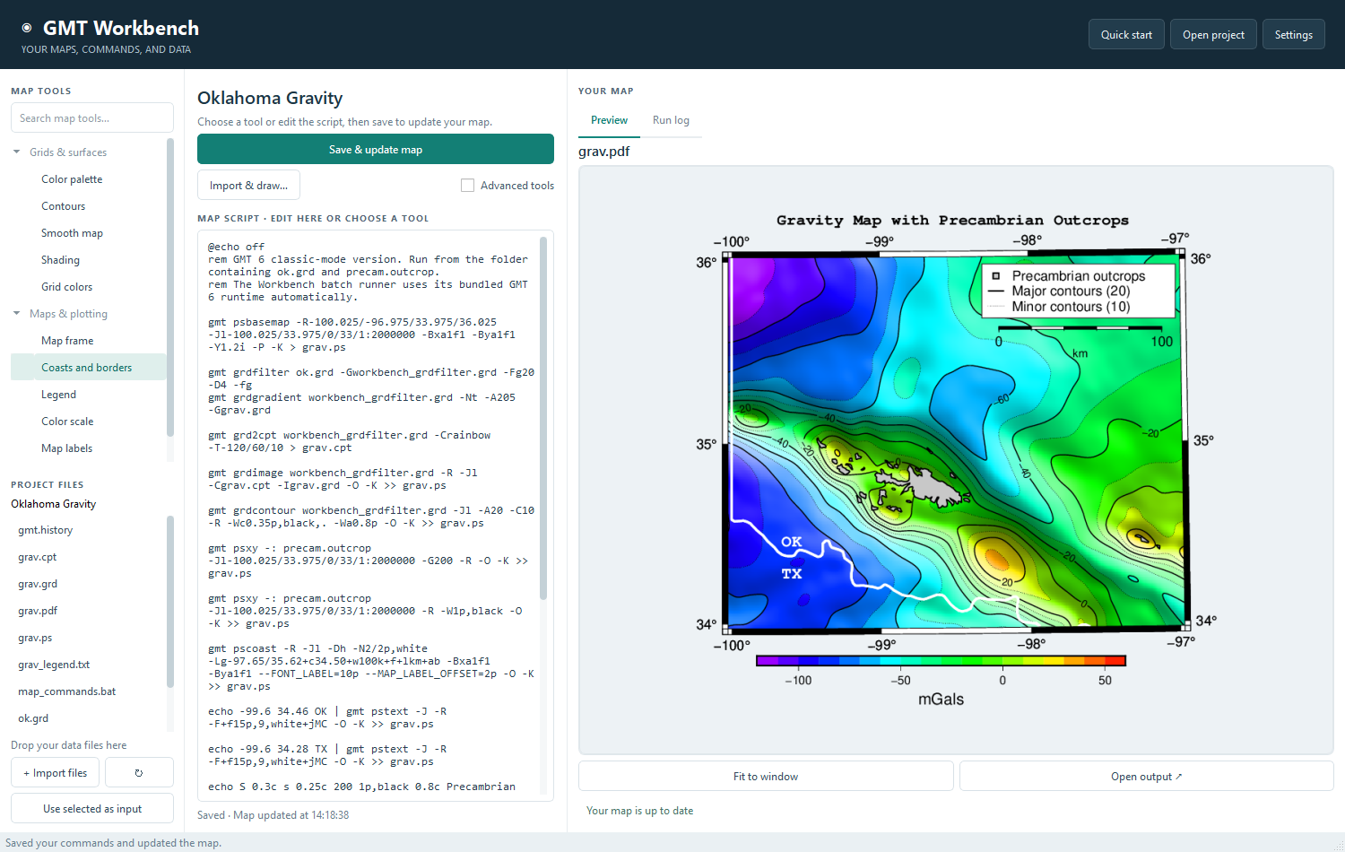
Start with the included Oklahoma map, choose a tool, and save your change. Your files, editable script, and larger map preview stay together in one local project.
Import native tables, grids, color palettes, and other GMT inputs. Open a .txt or .bat map script and run its supported commands from the workspace.
Select a tool in Map tools on the left. Review the proposed change, then click Save & update map to apply it and refresh the preview.
One save action · Larger map preview · Editable scriptsOpen Advanced tools for the full command options, reference, and workflow controls. Tools that need extra data or settings explain what you must supply.
139 documented tools · Full catalog accessPreview PostScript and PDF output, inspect logs, and return to previous runs. Your finished files remain available to open, share, or use in another application.
Original GMT output · Reusable workflowsTHE TOOLS INSIDE
The full Windows package includes the application and its supporting runtimes. No separate Python or GMT setup is needed. After installation, work with local data offline.
FROM DOWNLOAD TO DESKTOP
For Windows 10 or Windows 11, 64-bit. Use the complete installer to get the app and supporting files together.
Save the Windows setup file. It includes the runtimes, so this is a larger download than the application alone.
Open the installer and choose an installation folder. Windows may show an unsigned publisher notice; this release is not code-signed.
Start with the shared Oklahoma map—its script, data, and preview are included. Choose a tool and save to update the sample, or import your own files.
YOUR FIRST MAP UPDATE · SIX SHORT STEPS
Follow along in your installed Windows app. Choose a tool, review the change, and save to redraw the map. This website guide does not control the app or change your files.
This guide shows the version 1.2.0 workspace. The download card displays the release currently available.
STEP 1 / OPEN THE SAMPLE
After installation, open the Windows Start menu and launch GMT Workbench. The bundled Oklahoma Gravity workspace opens on first launch, with its files and map preview ready.
If you have opened another project, choose Open project in the top bar and select your copy of the sample folder:
%LOCALAPPDATA%\GMT Workbench\projects\Oklahoma Gravity
Your editable copy is separate from the installed sample.
STEP 2 / CHOOSE A MAP TOOL
In Map tools, search for Smooth map or grdfilter. Select the tool and read the explanation above your script.
The tool is ready to apply when you save. Choosing it alone does not redraw your map, so you can review the change first.
Some tools need another input file or a setting. Follow the message and use Advanced tools for those choices.
STEP 3 / EDIT IF YOU WANT TO
The Map script editor wraps long lines so you can read your commands beside the map. You can keep the script as it is, or make a small change before saving.
For a new title, find the line starting echo -98.5 36.20 and replace only these words:
Gravity Map with Precambrian OutcropsReplace withMy First Gravity MapKeep the coordinates, the | character, and surrounding command options.
STEP 4 / APPLY AND REDRAW
Use Save & update map above the script, or press Ctrl + S. This applies the ready tool and your script edits, saves the commands, and redraws the map.
Wait for the map-updated status before making another change. If a tool still needs data or settings, complete the choices shown in the app and save again.
The map updates when you save. Input files remain protected while generated map files are refreshed.
STEP 5 / CHECK THE RESULT
Look at Preview on the right. Check the map after smoothing and, if you changed the title, look for My First Gravity Map. Use Fit to window to see the full page.
Choose Open output to open the generated PDF. If an edit did not run, use Run log to find the reported problem, correct it, and save again.
The previous successful preview stays visible when a script edit cannot be parsed.
STEP 6 / BRING YOUR OWN MAP
Choose Import & draw… in Map script to open a .txt or .bat command file. Import its required data files into the project, too.
Use Advanced tools for individual command options, exact arguments, the reference, and workflow controls. These are available whenever your map needs more detail.
The original catalog remains accessible. Some scientific tools need particular datasets or settings and cannot be applied to every map automatically.
Step 1 of 6
Tip: use the left and right arrow keys while you are in this guide.
GET GMT WORKBENCH
Free for your own work or the classroom. No signup. Your project files stay on your computer.
Application, runtimes, and supporting files—plus the ready-to-edit Oklahoma map, its data, preview, and original shared archive.
Download Windows installerWindows 10 / 11 · 64-bit · Offline after installation
Download the application source for review or development. The Windows installer is the easiest way to run the complete app.
Download source ZIPThird-party notices included
Download the complete original okd archive separately for your own workspace or classroom. These shared files are also included with the installer.
Checking the release files…
A FEW PRACTICAL DETAILS
GMT Workbench is an independent desktop interface. It uses the original GMT engines for calculations and map generation. It is not an official GMT release. The included tools retain their own licenses and third-party notices.
Yes. Import a .bat or .txt script containing GMT commands. The importer supports bare commands, gmt module, echo text input, and output redirection. General shell programming, including variables and loops, is outside the supported import format.
The 139-command catalog and 1,613 option entries document GMT 4. Use Map script, the Advanced tab under Advanced tools, and version-specific online documentation for GMT 6 syntax. Some documented legacy helpers require additional compatible executables; see the included documentation for coverage and limits.
You need a connection to download the package. After installation, the included application and runtimes can work offline with local files. Online manuals and remote datasets still require a connection.
This page has no analytics, account forms, or file uploads. The desktop application works with local project files. Downloads are served by the website hosting provider.